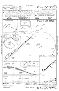
IAC chart of KANB
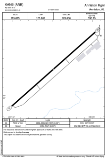
 ADC chart of KANB
 Satellite view of KANB

ADC chart of KANB
Satellite view of KANB
Sorry, we have no imagery here.
Sorry, we have no imagery here.
Sorry, we have no imagery here.
Sorry, we have no imagery here.
Sorry, we have no imagery here.
Sorry, we have no imagery here.
KANB - Anniston Rgnl
Located in Anniston, United States
ICAO - ANB, IATA - ANB
Data provided by AirmateGeneral information
Coordinates: N33°35'17" W85°51'29"
Elevation is 612 feet MSL.
Magnetic variation is -04° East View others Airports in Alabama
Operational data
Special qualification required
Current time UTC: 17:33:32
Current local time:
Weather
TAF: KANB 191723Z 1918/2018 23005KT P6SM SCT035 SCT100 FM200000 00000KT P6SM OVC250 FM201000 VRB04KT P6SM OVC025 FM201500 21007KT P6SM BKN035 AMD NOT SKED
Communications frequencies: [VIEW]
Runways:
| RWY identifier | QFU | Length (ft) | Width (ft) | Surface | LDA (ft) |
| 05 | 48° | 7000 | 150 | ASPH | |
| 23 | 228° | 7000 | 150 | ASPH |
Airport contact information
Address: Anniston United States