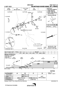
IAC chart of YMHU
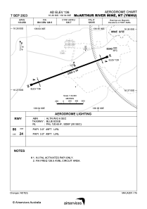
 ADC chart of YMHU
 Satellite view of YMHU
ADC chart of YMHU
Satellite view of YMHU
Sorry, we have no imagery here.
Sorry, we have no imagery here.
Sorry, we have no imagery here.
Sorry, we have no imagery here.
Sorry, we have no imagery here.


YMHU - Mcarthur River Mine
Located in Winnellie, Australia
ICAO - YMHU, IATA - MCV
Data provided by AirmateGeneral information
Coordinates: S16°26'36" E136°4'36"
Elevation is 136 feet MSL.
View others Airports in Northern Territory
Operational data
Special qualification required
Current time UTC:
Current local time:
Weather at : - ( 0 km )
METAR: KXER 302110Z AUTO 15011KT 3SM BR 24/24 A2988 RMK A01
Communications frequencies: [VIEW]
Runways:
| RWY identifier | QFU | Length (ft) | Width (ft) | Surface | LDA (ft) |
| 06 | 69° | 8202 | 98 | ASP | |
| 24 | 249° | 8202 | 98 | ASP |
Airport contact information
Address: Winnellie Australia
Satellite view of YMHU
Sorry, we have no imagery here.
Sorry, we have no imagery here.
Sorry, we have no imagery here.
Sorry, we have no imagery here.
Sorry, we have no imagery here.