IAC chart of YMGB
 ADC chart of YMGB
 Satellite view of YMGB
ADC chart of YMGB
Satellite view of YMGB
Sorry, we have no imagery here.
Sorry, we have no imagery here.
Sorry, we have no imagery here.
Sorry, we have no imagery here.
Sorry, we have no imagery here.
Sorry, we have no imagery here.


YMGB - Milingimbi
Located in Milingimbi, Australia
ICAO - YMGB, IATA - MGT
Data provided by AirmateGeneral information
Coordinates: S12°5'40" E134°53'37"
Elevation is 53 feet MSL.
View others Airports in Northern Territory
Operational data
Special qualification required
Current time UTC:
Current local time:
Weather at : - ( 0 km )
METAR: KXER 131510Z AUTO 16006KT 10SM 23/07 A3018 RMK A01
Communications frequencies: [VIEW]
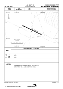
Runways:
| RWY identifier | QFU | Length (ft) | Width (ft) | Surface | LDA (ft) |
| 11 | 116° | 4626 | 98 | PER | |
| 29 | 296° | 4626 | 98 | PER |
Airport contact information
Address: Milingimbi Australia
Satellite view of YMGB
Sorry, we have no imagery here.
Sorry, we have no imagery here.
Sorry, we have no imagery here.
Sorry, we have no imagery here.
Sorry, we have no imagery here.
Sorry, we have no imagery here.