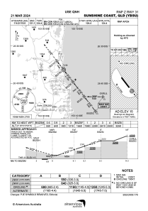
IAC chart of YBSU
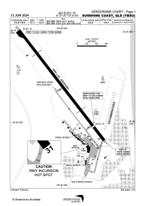
 ADC chart of YBSU
 Satellite view of YBSU
ADC chart of YBSU
Satellite view of YBSU
Sorry, we have no imagery here.
Sorry, we have no imagery here.
Sorry, we have no imagery here.
Sorry, we have no imagery here.
Sorry, we have no imagery here.
Sorry, we have no imagery here.


YBSU - Sunshine Coast
Located in Nambour, Australia
ICAO - , IATA - MCY
Data provided by AirmateGeneral information
Coordinates: S26°36'12" E153°5'28"
Elevation is 15 feet MSL.
View others Airports in Queensland
Operational data
Special qualification required
Current time UTC:
Current local time:
Weather at : - ( 0 km )
METAR: KAFP 190411Z AUTO 00000KT 10SM CLR 21/15 A2990 RMK AO2 T02100152
Communications frequencies: [VIEW]
Runways:
| RWY identifier | QFU | Length (ft) | Width (ft) | Surface | LDA (ft) |
| 13 | 142° | 9186 | 148 | UNK | |
| 31 | 322° | 9186 | 148 | UNK |
Airport contact information
Address: Nambour Australia
Other aviation service providers
Flight schools

Becker Helicopters Pilot Academy
Becker Helicopters Pilot Academy
fp@beckerhelicopters.com+61754570066
Aviation club (not for profit)

Sunshine Coast Aero Club
Sunshine Coast Aero Club
colin@ultimatethrillride.com.au+61414430647
+61414430647
+61414430647
Satellite view of YBSU
Sorry, we have no imagery here.
Sorry, we have no imagery here.
Sorry, we have no imagery here.
Sorry, we have no imagery here.
Sorry, we have no imagery here.
Sorry, we have no imagery here.