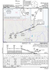
IAC chart of WIII
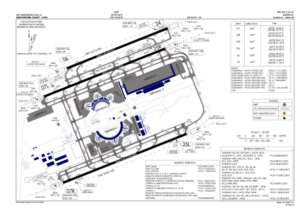
 ADC chart of WIII
 Satellite view of WIII
ADC chart of WIII
Satellite view of WIII
Sorry, we have no imagery here.
Sorry, we have no imagery here.
Sorry, we have no imagery here.
Sorry, we have no imagery here.
Sorry, we have no imagery here.
Sorry, we have no imagery here.


WIII - Jakarta / Soekarno Hatta Intl
Located in Jakarta, Indonesia
ICAO - WIII, IATA - CGK
Data provided by AirmateGeneral information
Coordinates: S6°7'25" E106°39'40"
Elevation is 34 feet MSL.
View others Airports in Banten
Operational data
Special qualification required
Current time UTC:
Current local time:
Weather
METAR: WIII 281930Z 23012KT 7000 -RA BKN020 25/23 Q1007 NOSIG
TAF: TAF AMD WIII 281900Z 2819/3000 22007KT 7000 SCT020 TEMPO 2819/2822 23008G18KT 5000 TSRA FEW018CB BKN020 BECMG 290 1/290334010KT
Communications frequencies: [VIEW]
Runways:
| RWY identifier | QFU | Length (ft) | Width (ft) | Surface | LDA (ft) |
| 07R | 68° | 12008 | 197 | CON | |
| 25L | 248° | 12008 | 197 | CON | |
| 07L | 68° | 11811 | 197 | CON | |
| 25R | 248° | 11811 | 197 | CON | |
| 06 | 68° | 9843 | 197 | UNK | |
| 24 | 248° | 9843 | 197 | UNK |
Airport contact information
Address: Jakarta Indonesia
Satellite view of WIII
Sorry, we have no imagery here.
Sorry, we have no imagery here.
Sorry, we have no imagery here.
Sorry, we have no imagery here.
Sorry, we have no imagery here.
Sorry, we have no imagery here.