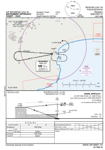
IAC chart of WICN
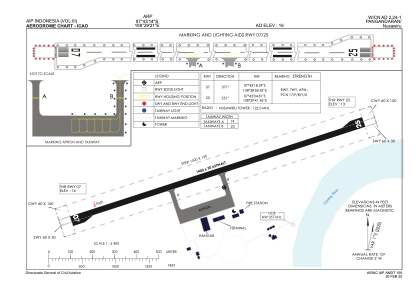
 ADC chart of WICN
 Satellite view of WICN
ADC chart of WICN
Satellite view of WICN
Sorry, we have no imagery here.
Sorry, we have no imagery here.
Sorry, we have no imagery here.
Sorry, we have no imagery here.
Sorry, we have no imagery here.
Sorry, we have no imagery here.


WICN - Pangandaran / Nusawiru
Located in Pangandaran, Indonesia
ICAO - , IATA - CJN
Data provided by AirmateGeneral information
Coordinates: S7°43'14" E108°29'21"
Elevation is 16 feet MSL.
View others Airports in Jawa Barat
Operational data
Special qualification required
Current time UTC:
Current local time:
Weather at : - ( 0 km )
METAR: KEVB 162347Z 31003KT 10SM FEW044 SCT050 23/23 A2993
Communications frequencies: [VIEW]
Runways:
| RWY identifier | QFU | Length (ft) | Width (ft) | Surface | LDA (ft) |
| 07 | 72° | 4593 | 98 | UNK | |
| 25 | 252° | 4593 | 98 | UNK |
Airport contact information
Address: Pangandaran Indonesia
Satellite view of WICN
Sorry, we have no imagery here.
Sorry, we have no imagery here.
Sorry, we have no imagery here.
Sorry, we have no imagery here.
Sorry, we have no imagery here.
Sorry, we have no imagery here.