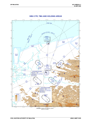
IAC chart of WBGS
 Satellite view of WBGS
Satellite view of WBGS
Sorry, we have no imagery here.
Sorry, we have no imagery here.
Sorry, we have no imagery here.
Sorry, we have no imagery here.
Sorry, we have no imagery here.
Sorry, we have no imagery here.


WBGS - Sibu
Located in Sibu, Malaysia
ICAO - WBGS, IATA - SBW
Data provided by AirmateGeneral information
Coordinates: N2°15'51" E111°58'57"
Elevation is 122 feet MSL.
View others Airports in Sarawak
Operational data
Special qualification required
Current time UTC:
Current local time:
Weather
METAR: WBGS 201800Z VRB01KT 9999 -RA SCT018 26/24 Q1008
TAF: TAF WBGS 201700Z 2018/2118 22005KT 9999 FEW018 TEMPO 2109/2112 5000 -TSRA FEW015CB SCT016
Communications frequencies: [VIEW]
Runways:
| RWY identifier | QFU | Length (ft) | Width (ft) | Surface | LDA (ft) |
| 13 | 130° | 9006 | 148 | ASP | |
| 31 | 310° | 9006 | 148 | ASP |
Airport contact information
Address: Sibu Malaysia
Satellite view of WBGS
Sorry, we have no imagery here.
Sorry, we have no imagery here.
Sorry, we have no imagery here.
Sorry, we have no imagery here.
Sorry, we have no imagery here.
Sorry, we have no imagery here.