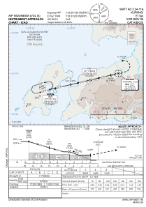
IAC chart of WATT
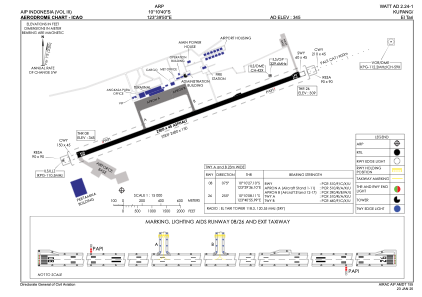
 ADC chart of WATT
 Satellite view of WATT
ADC chart of WATT
Satellite view of WATT
Sorry, we have no imagery here.
Sorry, we have no imagery here.
Sorry, we have no imagery here.
Sorry, we have no imagery here.
Sorry, we have no imagery here.
Sorry, we have no imagery here.


WATT - Kupang/El Tari
Located in West Kupang, Indonesia
ICAO - WATT, IATA - KOE
Data provided by AirmateGeneral information
Coordinates: S10°10'40" E123°39'50"
Elevation is 345 feet MSL.
View others Airports in Nusa Tenggara Timur
Operational data
Special qualification required
Current time UTC:
Current local time:
Weather
METAR: WATT 200500Z 10010KT 9999 SCT018 32/24 Q1009 NOSIG
Communications frequencies: [VIEW]
Runways:
| RWY identifier | QFU | Length (ft) | Width (ft) | Surface | LDA (ft) |
| 07 | 77° | 8202 | 148 | ASP | |
| 25 | 257° | 8202 | 148 | ASP | |
| 08 | 0° | 8202 | 148 | UNK | |
| 26 | 0° | 8202 | 148 | UNK |
Airport contact information
Address: West Kupang Indonesia
Satellite view of WATT
Sorry, we have no imagery here.
Sorry, we have no imagery here.
Sorry, we have no imagery here.
Sorry, we have no imagery here.
Sorry, we have no imagery here.
Sorry, we have no imagery here.