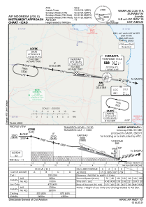
IAC chart of WARR
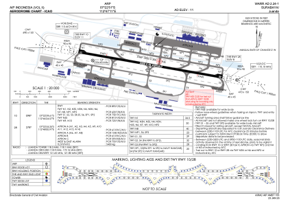
 ADC chart of WARR
 Satellite view of WARR
ADC chart of WARR
Satellite view of WARR
Sorry, we have no imagery here.
Sorry, we have no imagery here.
Sorry, we have no imagery here.
Sorry, we have no imagery here.
Sorry, we have no imagery here.


WARR - Surabaya/Juanda
Located in Surabaya, Indonesia
ICAO - WARR, IATA - SUB
Data provided by AirmateGeneral information
Coordinates: S7°22'51" E112°47'11"
Elevation is 11 feet MSL.
View others Airports in Jawa Timur
Operational data
Special qualification required
Current time UTC:
Current local time:
Weather
METAR: WARR 060500Z 05005KT 9999 FEW020 31/25 Q1010 NOSIG METAR
TAF: TAF WARR 052300Z 0600/0700 26005KT 5000 HZ FEW020 BECMG 0600/0602 09012KT 9999 NSW PROB40 TEMPO 0608/0612 4000 TSRA SCT018CB BECMG 0616/0618 26005KT 4000 HZ FEW020
Communications frequencies: [VIEW]
Runways:
| RWY identifier | QFU | Length (ft) | Width (ft) | Surface | LDA (ft) |
| 10 | 99° | 9843 | 148 | ASP | |
| 28 | 279° | 9843 | 148 | ASP |
Airport contact information
Address: Surabaya Indonesia
Satellite view of WARR
Sorry, we have no imagery here.
Sorry, we have no imagery here.
Sorry, we have no imagery here.
Sorry, we have no imagery here.
Sorry, we have no imagery here.