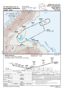
IAC chart of WAEG
 Satellite view of WAEG

Satellite view of WAEG
Sorry, we have no imagery here.
Sorry, we have no imagery here.
Sorry, we have no imagery here.
Sorry, we have no imagery here.
Sorry, we have no imagery here.
Sorry, we have no imagery here.


WAEG - North Halmahera / Gamar Malamo
Located in Tobelo, Indonesia
ICAO - , IATA - GLX
Data provided by AirmateGeneral information
Coordinates: N1°50'12" E127°47'13"
Elevation is 157 feet MSL.
View others Airports in Maluku Utara
Operational data
Special qualification required
Current time UTC:
Current local time:
Communications frequencies: [VIEW]
Runways:
| RWY identifier | QFU | Length (ft) | Width (ft) | Surface | LDA (ft) |
| 04 | 35° | 4593 | 98 | UNK | |
| 22 | 215° | 4593 | 98 | UNK |
Airport contact information
Address: Tobelo Indonesia
Satellite view of WAEG
Sorry, we have no imagery here.
Sorry, we have no imagery here.
Sorry, we have no imagery here.
Sorry, we have no imagery here.
Sorry, we have no imagery here.
Sorry, we have no imagery here.