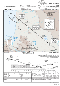
IAC chart of WADL
 Satellite view of WADL
Satellite view of WADL
Sorry, we have no imagery here.
Sorry, we have no imagery here.
Sorry, we have no imagery here.
Sorry, we have no imagery here.
Sorry, we have no imagery here.
Sorry, we have no imagery here.


WADL - Praya / Zainuddin Abdul Madjid
Located in Praya, Indonesia
ICAO - WADL, IATA - LOP
Data provided by AirmateGeneral information
Coordinates: S8°45'26" E116°16'36"
Elevation is 343 feet MSL.
View others Airports in Nusa Tenggara Barat
Operational data
Special qualification required
Current time UTC:
Current local time:
Weather
TAF: TAF WADL 101100Z 1012/1112 17005KT 6000 BKN016 TEMPO 1012/1015 4000 -RA FEW015CB BECMG 1015/1017 SCT016
Communications frequencies: [VIEW]
Runways:
| RWY identifier | QFU | Length (ft) | Width (ft) | Surface | LDA (ft) |
| 13 | 129° | 10827 | 148 | Asphalt | |
| 31 | 309° | 10827 | 148 | Asphalt |
Airport contact information
Address: Praya Indonesia
Satellite view of WADL
Sorry, we have no imagery here.
Sorry, we have no imagery here.
Sorry, we have no imagery here.
Sorry, we have no imagery here.
Sorry, we have no imagery here.
Sorry, we have no imagery here.