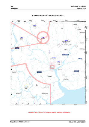
VAC chart of VYYY
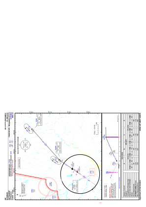
 IAC chart of VYYY
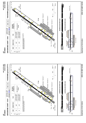
 ADC chart of VYYY
 Satellite view of VYYY
IAC chart of VYYYADC chart of VYYY
Satellite view of VYYY
Sorry, we have no imagery here.
Sorry, we have no imagery here.
Sorry, we have no imagery here.
Sorry, we have no imagery here.
Sorry, we have no imagery here.
Sorry, we have no imagery here.


VYYY - Yangon / Yangon International
Located in Yangon, Myanmar
ICAO - VYYY, IATA - RGN
Data provided by AirmateGeneral information
Coordinates: N16°54'26" E96°7'60"
Elevation is 110 feet MSL.
View others Airports in Yangon Division
Operational data
Special qualification required
Current time UTC:
Current local time:
Weather
METAR: VYYY 121800Z 00000KT 6000 BKN016 FEW020CB OVC100 25/23 Q1009 NOSIG
TAF: TAF VYYY 121700Z 1218/1318 22006KT 7000 BKN015 FEW020CB BKN100 TX36/1308Z TN24/1223Z TEMPO 1218/1224 20005KT 5000 -RA BKN014 FEW018CB OVC090
Communications frequencies: [VIEW]
Runways:
| RWY identifier | QFU | Length (ft) | Width (ft) | Surface | LDA (ft) |
| 03 | 34° | 11201 | 197 | ASP | |
| 21 | 214° | 11201 | 197 | ASP |
Airport contact information
Address: Yangon Myanmar
Satellite view of VYYY
Sorry, we have no imagery here.
Sorry, we have no imagery here.
Sorry, we have no imagery here.
Sorry, we have no imagery here.
Sorry, we have no imagery here.
Sorry, we have no imagery here.