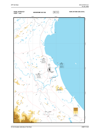
VAC chart of VVVH
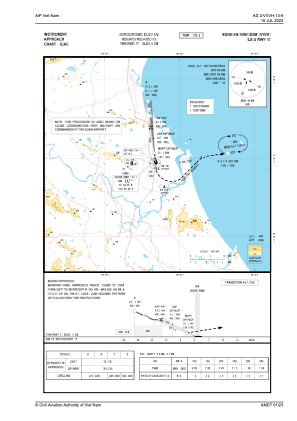
 IAC chart of VVVH
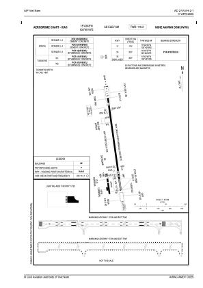
 ADC chart of VVVH
 Satellite view of VVVH
IAC chart of VVVHADC chart of VVVH
Satellite view of VVVH
Sorry, we have no imagery here.
Sorry, we have no imagery here.
Sorry, we have no imagery here.
Sorry, we have no imagery here.
Sorry, we have no imagery here.
Sorry, we have no imagery here.


VVVH - Vinh Airport
Located in Vinh, Viet Nam
ICAO - VVVH, IATA - VII
Data provided by AirmateGeneral information
Coordinates: N18°43'48" E105°40'18"
Elevation is 23 feet MSL.
View others Airports in Thua Thien-Hue
Operational data
Special qualification required
Current time UTC:
Current local time:
Communications frequencies: [VIEW]
Runways:
| RWY identifier | QFU | Length (ft) | Width (ft) | Surface | LDA (ft) |
| 17 | 173° | 7875 | 148 | ASP | |
| 35 | 353° | 7875 | 148 | ASP |
Airport contact information
Address: Vinh Viet Nam
Satellite view of VVVH
Sorry, we have no imagery here.
Sorry, we have no imagery here.
Sorry, we have no imagery here.
Sorry, we have no imagery here.
Sorry, we have no imagery here.
Sorry, we have no imagery here.