VAC chart of VVPQ
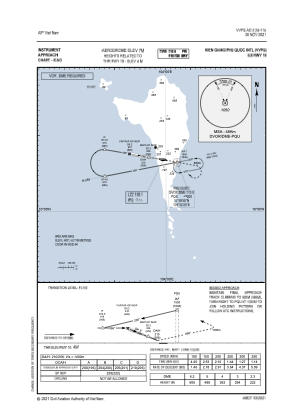
 IAC chart of VVPQ
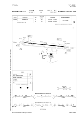
 ADC chart of VVPQ
 Satellite view of VVPQ

IAC chart of VVPQADC chart of VVPQ
Satellite view of VVPQ
Sorry, we have no imagery here.
Sorry, we have no imagery here.
Sorry, we have no imagery here.
Sorry, we have no imagery here.
Sorry, we have no imagery here.
Sorry, we have no imagery here.


VVPQ - Kien Giang / Phu Quoc International
Located in Duong Dong, Viet Nam
ICAO - VVPQ, IATA - PQC
Data provided by AirmateGeneral information
Coordinates: N10°10'11" E103°59'35"
Elevation is 23 feet MSL.
View others Airports in Kien Giang
Operational data
Special qualification required
Current time UTC:
Current local time:
Weather
METAR: VVPQ 170100Z 10007KT 9999 SCT015 27/23 Q1011 NOSIG
TAF: TAF VVPQ 162300Z 1700/1724 10008KT 9999 SCT017 SCT040 TEMPO 1716/1721 5000 TSRA BKN015 FEW017CB
Communications frequencies: [VIEW]
Runways:
| RWY identifier | QFU | Length (ft) | Width (ft) | Surface | LDA (ft) |
| 10 | 96° | 9843 | 148 | UNK | |
| 28 | 276° | 9843 | 148 | UNK |
Airport contact information
Address: Duong Dong Viet Nam
Satellite view of VVPQ
Sorry, we have no imagery here.
Sorry, we have no imagery here.
Sorry, we have no imagery here.
Sorry, we have no imagery here.
Sorry, we have no imagery here.
Sorry, we have no imagery here.