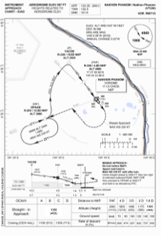
IAC chart of VTUW
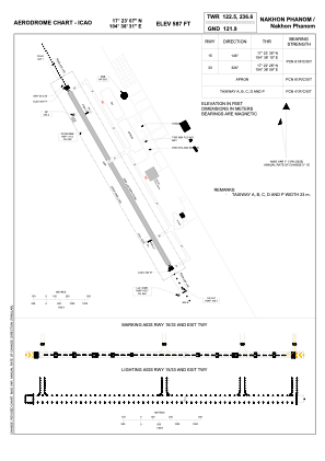
 ADC chart of VTUW
 Satellite view of VTUW

ADC chart of VTUW
Satellite view of VTUW
Sorry, we have no imagery here.
Sorry, we have no imagery here.
Sorry, we have no imagery here.
Sorry, we have no imagery here.
Sorry, we have no imagery here.
Sorry, we have no imagery here.


VTUW - Nakhon Phanom / Nakhon Phanom Airport
Located in Nakhon Phanom, Thailand
ICAO - VTUW, IATA - KOP
Data provided by AirmateGeneral information
Coordinates: N17°23'7" E104°38'31"
Elevation is 587 feet MSL.
View others Airports in Nakhon Phanom Province
Operational data
Special qualification required
Current time UTC:
Current local time:
Weather
METAR: VTUW 170100Z 12005KT 090V150 CAVOK 22/14 Q1016 NOSIG
TAF: TAF VTUW 162300Z 1700/1724 09005KT 8000 FEW030
Communications frequencies: [VIEW]
Runways:
| RWY identifier | QFU | Length (ft) | Width (ft) | Surface | LDA (ft) |
| 15 | 145° | 8202 | 148 | ASP | |
| 33 | 325° | 8202 | 148 | ASP |
Airport contact information
Address: Nakhon Phanom Thailand
Other aviation service providers
Aviation club (not for profit)

International Aviation College - Nakhon Phanom University
International Aviation College - Nakhon Phanom University
iac@npu.ac.th6642531575
Satellite view of VTUW
Sorry, we have no imagery here.
Sorry, we have no imagery here.
Sorry, we have no imagery here.
Sorry, we have no imagery here.
Sorry, we have no imagery here.
Sorry, we have no imagery here.