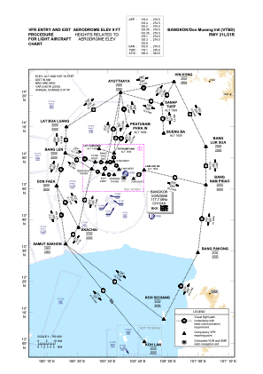
VAC chart of VTBD
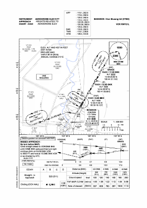
 IAC chart of VTBD
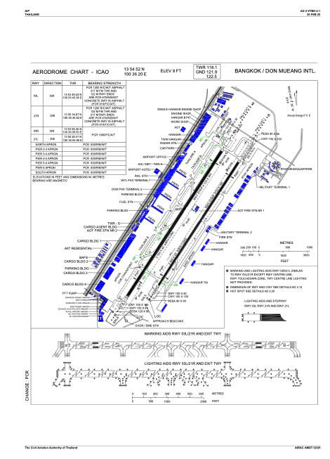
 ADC chart of VTBD
 Satellite view of VTBD
IAC chart of VTBDADC chart of VTBD
Satellite view of VTBD
Sorry, we have no imagery here.
Sorry, we have no imagery here.
Sorry, we have no imagery here.
Sorry, we have no imagery here.
Sorry, we have no imagery here.
Sorry, we have no imagery here.


VTBD - Bangkok / Don Mueang Intl Airport
Located in Bangkok, Thailand
ICAO - VTBD, IATA - DMK
Data provided by AirmateGeneral information
Coordinates: N13°54'52" E100°36'20"
Elevation is 9 feet MSL.
Magnetic variation is -1° East View others Airports in Bangkok Province
Operational data
Special qualification required
Current time UTC:
Current local time:
Weather
METAR: VTBD 091100Z 18011KT 9999 FEW030 32/22 Q1006 NOSIG
TAF: TAF VTBD 090500Z 0906/1012 19008KT 9999 FEW020
Communications frequencies: [VIEW]
Runways:
| RWY identifier | QFU | Length (ft) | Width (ft) | Surface | LDA (ft) |
| 03R | 28° | 11483 | 148 | ASPH | 11483 |
| 21L | 208° | 11483 | 148 | ASPH | 10335 |
| 03L | 29° | 12139 | 197 | ASPH | 12139 |
| 21R | 209° | 12139 | 197 | ASPH | 12139 |
Airport contact information
Address: Bangkok Thailand
Satellite view of VTBD
Sorry, we have no imagery here.
Sorry, we have no imagery here.
Sorry, we have no imagery here.
Sorry, we have no imagery here.
Sorry, we have no imagery here.
Sorry, we have no imagery here.