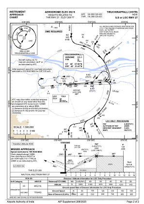
IAC chart of VOTR
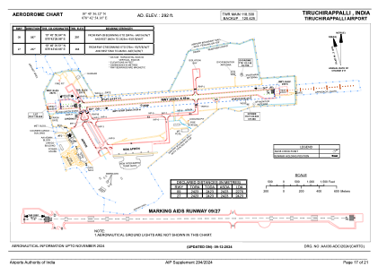
 ADC chart of VOTR
 Satellite view of VOTR
ADC chart of VOTR
Satellite view of VOTR
Sorry, we have no imagery here.
Sorry, we have no imagery here.
Sorry, we have no imagery here.
Sorry, we have no imagery here.
Sorry, we have no imagery here.
Sorry, we have no imagery here.


VOTR - Tiruchirappalli Airport, Tiruchirappalli
Located in Tiruchirappalli, India
ICAO - VOTR, IATA - TRZ
Data provided by AirmateGeneral information
Coordinates: N10°45'56" E78°42'54"
Elevation is 290 feet MSL.
View others Airports in Tamil Nadu
Operational data
Special qualification required
Current time UTC:
Current local time:
Weather
METAR: VOTR 131100Z 25011KT 6000 FEW016 BKN100 33/24 Q1004 NOSIG
TAF: TAF VOTR 131100Z 1312/1418 27010KT 5000 BR SCT020 BKN100 BECMG 1403/1404 27010G20KT 6000 TEMPO 1409/1415 SCT020 FEW025TCU/CB BKN100 BECMG 1415/1416 27010KT 5000 BR
Communications frequencies: [VIEW]
Runways:
| RWY identifier | QFU | Length (ft) | Width (ft) | Surface | LDA (ft) |
| 09 | 85° | 7949 | 148 | ASP | |
| 27 | 265° | 7949 | 148 | ASP |
Airport contact information
Address: Tiruchirappalli India
Satellite view of VOTR
Sorry, we have no imagery here.
Sorry, we have no imagery here.
Sorry, we have no imagery here.
Sorry, we have no imagery here.
Sorry, we have no imagery here.
Sorry, we have no imagery here.