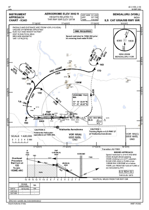
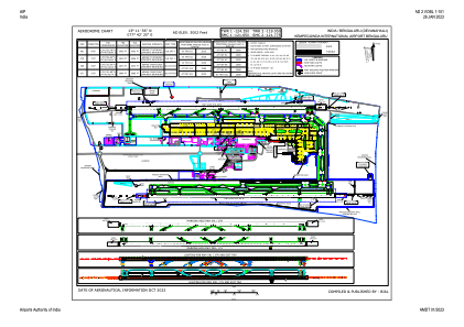


VOBL - Kempegowda International Airport, Bengaluru
Located in Bengaluru, India
ICAO - VOBL, IATA - BLR
Data provided by AirmateGeneral information
Coordinates: N13°11'56" E77°42'20"
Elevation is 3001 feet MSL.
View others Airports in Karnataka
Operational data
Special qualification required
Current time UTC:
Current local time:
Weather
METAR: VOBL 250130Z 25008KT 6000 BKN008 SCT080 22/19 Q1011 NOSIG
TAF: TAF VOBL 242300Z 2500/2606 29010KT 6000 SCT012 SCT080 TEMPO 2500/2503 5000 BR BKN008 SCT012 BKN080 TEMPO 2509/2515 3000 RA DZ SCT012 SCT020 FEW025CB BKN080 TEMPO 2600/2603 5000 BR BKN008 SCT012 BKN080
Communications frequencies: [VIEW]
Runways:
| RWY identifier | QFU | Length (ft) | Width (ft) | Surface | LDA (ft) |
| 09R | 91° | 13123 | 148 | UNK | |
| 27L | 271° | 13123 | 148 | UNK | |
| 09L | 91° | 13123 | 148 | UNK | |
| 27R | 271° | 13123 | 148 | UNK |
Airport contact information
Address: Bengaluru India