VAC chart of VNKT
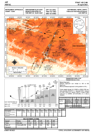
 IAC chart of VNKT
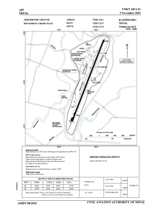
 ADC chart of VNKT
 Satellite view of VNKT
IAC chart of VNKTADC chart of VNKT
Satellite view of VNKT
Sorry, we have no imagery here.
Sorry, we have no imagery here.
Sorry, we have no imagery here.
Sorry, we have no imagery here.
Sorry, we have no imagery here.
Sorry, we have no imagery here.


VNKT - Tribhuvan Intl
Located in Kathmandu, Nepal
ICAO - VNKT, IATA - KTM
Data provided by AirmateGeneral information
Coordinates: N27°41'46" E85°21'38"
Elevation is 4395 feet MSL.
View others Airports in Bagmati
Operational data
Special qualification required
Current time UTC:
Current local time:
Weather
METAR: VNKT 290530Z VRB02KT 6000 FEW015 28/06 Q1014 NOSIG
TAF: TAF VNKT 290500Z 2906/3006 25005KT 6000 FEW015 BECMG 2907/2908 28011KT 7000 PROB30 2908/2912 28011G21KT BECMG 2914/2915 21004KT 6000 BECMG 3000/3003 VRB02KT 4000 BR PROB30 3001/3003 2000 BR/HZ BECMG 3004/3005 11004KT 4000 HZ
Communications frequencies: [VIEW]
Runways:
| RWY identifier | QFU | Length (ft) | Width (ft) | Surface | LDA (ft) |
| 02 | 22° | 10085 | 148 | ASP | |
| 20 | 202° | 10085 | 148 | ASP |
Airport contact information
Address: Kathmandu Nepal
Satellite view of VNKT
Sorry, we have no imagery here.
Sorry, we have no imagery here.
Sorry, we have no imagery here.
Sorry, we have no imagery here.
Sorry, we have no imagery here.
Sorry, we have no imagery here.