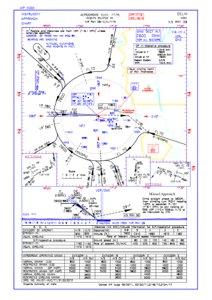
IAC chart of VIDP
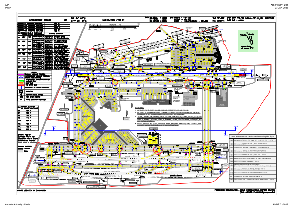
 ADC chart of VIDP
 Satellite view of VIDP
ADC chart of VIDP
Satellite view of VIDP
Sorry, we have no imagery here.
Sorry, we have no imagery here.
Sorry, we have no imagery here.
Sorry, we have no imagery here.
Sorry, we have no imagery here.
Sorry, we have no imagery here.


VIDP - Indira Gandhi International Airport, Delhi
Located in Delhi, India
ICAO - VIDP, IATA - DEL
Data provided by AirmateGeneral information
Coordinates: N28°34'7" E77°6'44"
Elevation is 778 feet MSL.
View others Airports in Delhi
Operational data
Special qualification required
Current time UTC:
Current local time:
Weather
METAR: VIDP 291430Z 27008KT 4500 HZ FEW040 SCT100 24/03 Q1010 NOSIG
TAF: TAF VIDP 291400Z 2915/2924 29008KT 4000 HZ SCT100 BECMG 2920/2922 32006KT 3000 HZ FEW100
Communications frequencies: [VIEW]
Runways:
| RWY identifier | QFU | Length (ft) | Width (ft) | Surface | LDA (ft) |
| 09 | 91° | 9239 | 148 | ASP | |
| 27 | 271° | 9239 | 148 | ASP | |
| 10 | 104° | 12510 | 148 | ASP | |
| 28 | 284° | 12510 | 148 | ASP | |
| 11R | 103° | 14534 | 197 | UNK | |
| 29L | 283° | 14534 | 197 | UNK | |
| 11L | 104° | 13681 | 148 | UNK | |
| 29R | 284° | 13681 | 148 | UNK |
Airport contact information
Address: Delhi India
Satellite view of VIDP
Sorry, we have no imagery here.
Sorry, we have no imagery here.
Sorry, we have no imagery here.
Sorry, we have no imagery here.
Sorry, we have no imagery here.
Sorry, we have no imagery here.