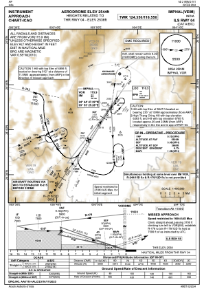
IAC chart of VEIM
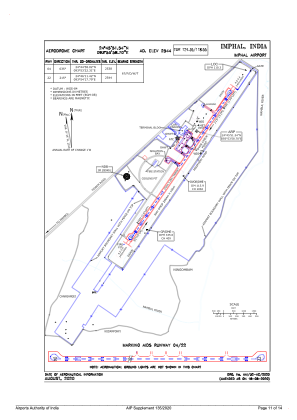
 ADC chart of VEIM
 Satellite view of VEIM
ADC chart of VEIM
Satellite view of VEIM
Sorry, we have no imagery here.
Sorry, we have no imagery here.
Sorry, we have no imagery here.
Sorry, we have no imagery here.
Sorry, we have no imagery here.
Sorry, we have no imagery here.


VEIM - Imphal
Located in Imphal, India
ICAO - VEIM, IATA - IMF
Data provided by AirmateGeneral information
Coordinates: N24°45'48" E93°53'56"
Elevation is 2540 feet MSL.
Magnetic variation is -1° East View others Airports in Manipur
Operational data
Special qualification required
Current time UTC:
Current local time:
Weather
METAR: VEIM 220900Z 34004KT 4500 BR FEW010 SCT018 BKN090 26/21 Q1011 NOSIG
TAF: TAF VEIM 220800Z 2209/2218 34006KT 4000 HZ FEW010 SCT018 BKN090 TEMPO 2210/2213 27010G20KT 1500 -TSRA SCT018 FEW025CB OVC090 BECMG 2213/2215 00000KT 3000 -RA BR SCT018 BKN090
Communications frequencies: [VIEW]
Runways:
| RWY identifier | QFU | Length (ft) | Width (ft) | Surface | LDA (ft) |
| 04 | 34° | 9010 | 146 | ASPH | |
| 22 | 214° | 9010 | 146 | ASPH |
Airport contact information
Address: Imphal India