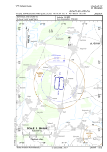
VAC chart of UKAC
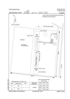
 ADC chart of UKAC
 Satellite view of UKAC
ADC chart of UKAC
Satellite view of UKAC
Sorry, we have no imagery here.
Sorry, we have no imagery here.
Sorry, we have no imagery here.
Sorry, we have no imagery here.
Sorry, we have no imagery here.
Sorry, we have no imagery here.


UKAC - Chemer
Located in Prohres, Ukraine
ICAO - , IATA -
Data provided by AirmateGeneral information
Coordinates: N51°7'1" E31°9'14"
Elevation is 426 feet MSL.
Magnetic variation is 7° East View others Airports in Chernihiv
Operational data
Special qualification required
Current time UTC:
Current local time:
Weather at : - ( 0 km )
METAR: ZMUB 251300Z 15003MPS 9999 FEW030CB FEW033 13/00 Q1015 NOSIG RMK QFE653.9 45 MOP
Communications frequencies: [VIEW]
Runways:
| RWY identifier | QFU | Length (ft) | Width (ft) | Surface | LDA (ft) |
| 36 | 22° | 3407 | 182 | GRASS | 3281 |
| 18 | 202° | 3406 | 182 | GRASS | 3281 |
Airport contact information
Address: Prohres Ukraine
Satellite view of UKAC
Sorry, we have no imagery here.
Sorry, we have no imagery here.
Sorry, we have no imagery here.
Sorry, we have no imagery here.
Sorry, we have no imagery here.
Sorry, we have no imagery here.