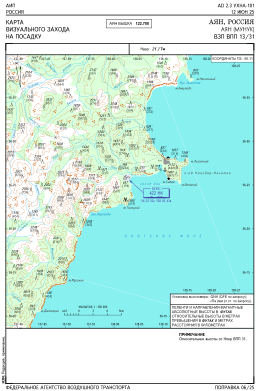
VAC chart of UHNA
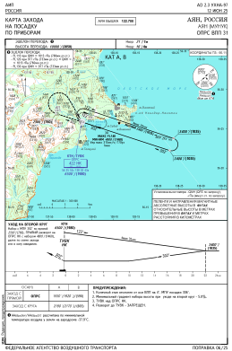
 IAC chart of UHNA
 ADC chart of UHNA
 Satellite view of UHNA
IAC chart of UHNAADC chart of UHNA
Satellite view of UHNA
Sorry, we have no imagery here.
Sorry, we have no imagery here.
Sorry, we have no imagery here.
Sorry, we have no imagery here.
Sorry, we have no imagery here.
Sorry, we have no imagery here.


UHNA - Munuk
Located in Ayan, Russian Federation
ICAO - UHNA, IATA -
Data provided by AirmateGeneral information
Coordinates: N56°25'56" E138°2'44"
Elevation is 21 feet MSL.
Magnetic variation is -14° East View others Airports in Khabarovsk Krai
Operational data
Special qualification required
Current time UTC:
Current local time:
Weather at : - ( 0 km )
METAR: CYZT 231102Z VRB02KT 6SM BR FEW010 OVC016 12/11 A3011 RMK SF2SC6 SLP197
Communications frequencies: [VIEW]
Runways:
| RWY identifier | QFU | Length (ft) | Width (ft) | Surface | LDA (ft) |
| 13 | 112° | 3117 | 197 | DIRT | 3117 |
| 31 | 292° | 3117 | 197 | DIRT | 3117 |
Airport contact information
Address: Ayan Russian Federation
Satellite view of UHNA
Sorry, we have no imagery here.
Sorry, we have no imagery here.
Sorry, we have no imagery here.
Sorry, we have no imagery here.
Sorry, we have no imagery here.
Sorry, we have no imagery here.