VAC chart of TNCA
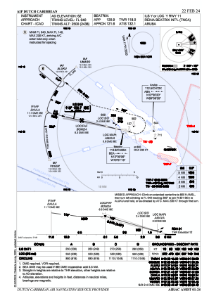
 IAC chart of TNCA
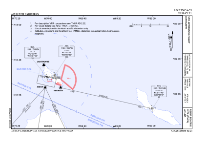
 ADC chart of TNCA
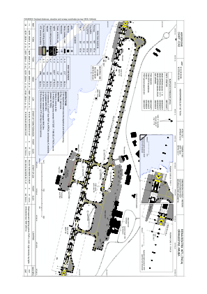 Satellite view of TNCA
IAC chart of TNCAADC chart of TNCA
Satellite view of TNCA
Sorry, we have no imagery here.
Sorry, we have no imagery here.
Sorry, we have no imagery here.
Sorry, we have no imagery here.
Sorry, we have no imagery here.
Sorry, we have no imagery here.


TNCA - International Reina Beatrix Airport
Located in Oranjestad, Aruba
ICAO - TNCA, IATA - AUA
Data provided by AirmateGeneral information
Coordinates: N12°30'5" W70°0'55"
Elevation is 62 feet MSL.
Magnetic variation is -11° East View others Airports in (unassigned)
Operational data
Special qualification required
Current time UTC:
Current local time:
Weather
METAR: TNCA 290400Z 09018KT 9999 FEW017 27/22 Q1013 NOSIG
TAF: TAF TNCA 282316Z 2900/2924 08022KT 9999 SCT020
Communications frequencies: [VIEW]
Runways:
| RWY identifier | QFU | Length (ft) | Width (ft) | Surface | LDA (ft) |
| 11 | 104° | 9278 | 148 | ASP | |
| 29 | 284° | 9278 | 148 | ASP |
Airport contact information
Address: Oranjestad Aruba
Satellite view of TNCA
Sorry, we have no imagery here.
Sorry, we have no imagery here.
Sorry, we have no imagery here.
Sorry, we have no imagery here.
Sorry, we have no imagery here.
Sorry, we have no imagery here.