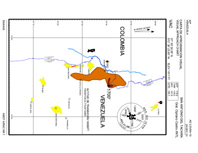
VAC chart of SVSA
 IAC chart of SVSA
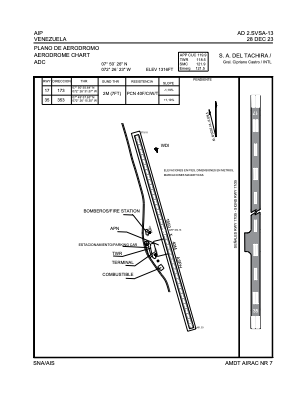
 ADC chart of SVSA
 Satellite view of SVSA
IAC chart of SVSAADC chart of SVSA
Satellite view of SVSA
Sorry, we have no imagery here.
Sorry, we have no imagery here.
Sorry, we have no imagery here.
Sorry, we have no imagery here.
Sorry, we have no imagery here.
Sorry, we have no imagery here.


SVSA - Aeropuerto Internacional Gral. Cipriano Castro - Intl
Located in San Antonio Del Tachira, Venezuela
ICAO - SVSA, IATA - SVZ
Data provided by AirmateGeneral information
Coordinates: N7°50'26" W72°26'23"
Elevation is 1317 feet MSL.
Magnetic variation is -9° East View others Airports in Tachira
Operational data
Special qualification required
Current time UTC:
Current local time:
Communications frequencies: [VIEW]
Runways:
| RWY identifier | QFU | Length (ft) | Width (ft) | Surface | LDA (ft) |
| 17 | 165° | 6063 | 127 | ASPH | 6070 |
| 35 | 345° | 6063 | 127 | ASPH | 6070 |
Airport contact information
Address: San Antonio Del Tachira Venezuela
Satellite view of SVSA
Sorry, we have no imagery here.
Sorry, we have no imagery here.
Sorry, we have no imagery here.
Sorry, we have no imagery here.
Sorry, we have no imagery here.
Sorry, we have no imagery here.