VAC chart of SPUR
 IAC chart of SPUR
 Satellite view of SPUR
IAC chart of SPUR
Satellite view of SPUR
Sorry, we have no imagery here.
Sorry, we have no imagery here.
Sorry, we have no imagery here.
Sorry, we have no imagery here.
Sorry, we have no imagery here.


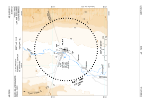
SPUR - Capitan Fap Guillermo Concha Iberico
Located in Piura, Peru
ICAO - SPUR, IATA - PIU
Data provided by AirmateGeneral information
Coordinates: S5°12'21" W80°36'59"
Elevation is 116 feet MSL.
View others Airports in Piura Region
Operational data
Special qualification required
Current time UTC:
Current local time:
Weather
METAR: SPUR 191200Z 15008KT 9999 BKN009 20/17 Q1013 RMK TN19.4 BIRD HAZARD RWY 19/01 PP000
TAF: TAF SPUR 191110Z 1912/2012 18005KT 9999 OVC009 TX31/1919Z TN21/2011Z BECMG 1913/1915 SCT015 BECMG 1918/1920 20015KT BECMG 2004/2006 16005KT
Communications frequencies: [VIEW]
Runways:
| RWY identifier | QFU | Length (ft) | Width (ft) | Surface | LDA (ft) |
| 01 | 13° | 8202 | 148 | ASP | |
| 19 | 193° | 8202 | 148 | ASP | |
| 01R | 0° | 7024 | 98 | UNK | |
| 19L | 0° | 7024 | 98 | UNK |
Airport contact information
Address: Piura Peru
Satellite view of SPUR
Sorry, we have no imagery here.
Sorry, we have no imagery here.
Sorry, we have no imagery here.
Sorry, we have no imagery here.
Sorry, we have no imagery here.