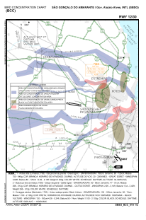
VAC chart of SBSG
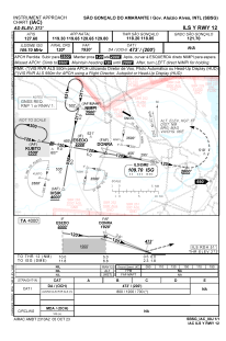
 IAC chart of SBSG
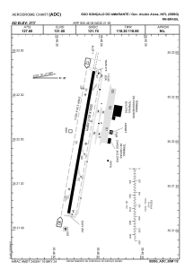
 ADC chart of SBSG
 Satellite view of SBSG
IAC chart of SBSGADC chart of SBSG
Satellite view of SBSG
Sorry, we have no imagery here.
Sorry, we have no imagery here.
Sorry, we have no imagery here.
Sorry, we have no imagery here.
Sorry, we have no imagery here.
Sorry, we have no imagery here.


SBSG - São Gonçalo Do Amarante - Governador Aluizio Alves
Located in Natal, Brazil
ICAO - SBSG, IATA - NAT
Data provided by AirmateGeneral information
Coordinates: S5°46'8" W35°21'59"
Elevation is 273 feet MSL.
Magnetic variation is -20.783333333° East View others Airports in Rio Grande do Norte
Operational data
Special qualification required
Current time UTC:
Current local time:
Weather
METAR: SBSG 021800Z 08011KT 9999 FEW015 SCT020 FEW025TCU 26/24 Q1010
TAF: TAF SBSG 021650Z 0218/0318 13008KT 8000 SCT023 TN23/0308Z TX30/0318Z TEMPO 0218/0222 09013KT 6000 BKN020 FEW025TCU BECMG 0222/0224 15005KT TEMPO 0302/0311 21005KT 6000 SCT007 BKN016 BECMG 0312/0314 12013KT RMK PHC
Communications frequencies: [VIEW]
Runways:
| RWY identifier | QFU | Length (ft) | Width (ft) | Surface | LDA (ft) |
| 12 | 99° | 10236 | 984 | ASPH | |
| 30 | 279° | 10236 | 984 | ASPH |
Airport contact information
Address: Natal Brazil
Satellite view of SBSG
Sorry, we have no imagery here.
Sorry, we have no imagery here.
Sorry, we have no imagery here.
Sorry, we have no imagery here.
Sorry, we have no imagery here.
Sorry, we have no imagery here.