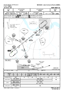
IAC chart of SBMA
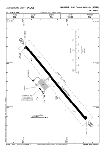
 ADC chart of SBMA
 Satellite view of SBMA
ADC chart of SBMA
Satellite view of SBMA
Sorry, we have no imagery here.
Sorry, we have no imagery here.
Sorry, we have no imagery here.
Sorry, we have no imagery here.
Sorry, we have no imagery here.
Sorry, we have no imagery here.


SBMA - João Correa Da Rocha
Located in Marabá, Brazil
ICAO - SBMA, IATA - MAB
Data provided by AirmateGeneral information
Coordinates: S5°22'5" W49°8'17"
Elevation is 357 feet MSL.
Magnetic variation is -20.713747341° East View others Airports in Pará
Operational data
Special qualification required
Current time UTC:
Current local time:
Weather
METAR: SBMA 191300Z 15003KT CAVOK 31/25 Q1013
TAF: TAF SBMA 190834Z 1912/1924 30005KT 6000 FEW020 TX34/1918Z TN27/1924Z BECMG 1914/1916 12007KT SCT020 FEW025TCU BECMG 1920/1922 28005KT FEW020 RMK PGA
Communications frequencies: [VIEW]
Runways:
| RWY identifier | QFU | Length (ft) | Width (ft) | Surface | LDA (ft) |
| 25 | 0° | 6562 | 148 | ASPH | |
| 07 | 0° | 6562 | 148 | ASPH |
Airport contact information
Address: Marabá Brazil
Satellite view of SBMA
Sorry, we have no imagery here.
Sorry, we have no imagery here.
Sorry, we have no imagery here.
Sorry, we have no imagery here.
Sorry, we have no imagery here.
Sorry, we have no imagery here.