VAC chart of SBBH
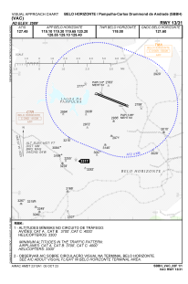 IAC chart of SBBH
 ADC chart of SBBH
 Satellite view of SBBH
IAC chart of SBBHADC chart of SBBH
Satellite view of SBBH
Sorry, we have no imagery here.
Sorry, we have no imagery here.
Sorry, we have no imagery here.
Sorry, we have no imagery here.
Sorry, we have no imagery here.
Sorry, we have no imagery here.


SBBH - Pampulha - Carlos Drummond De Andrade
Located in Belo Horizonte, Brazil
ICAO - SBBH, IATA - PLU
Data provided by AirmateGeneral information
Coordinates: S19°51'7" W43°57'2"
Elevation is 2588 feet MSL.
Magnetic variation is -23.05° East View others Airports in Minas Gerais
Operational data
Special qualification required
Current time UTC:
Current local time:
Weather
METAR: SBBH 302100Z 10006KT 9999 FEW049 SCT065 26/19 Q1015
Communications frequencies: [VIEW]
Runways:
| RWY identifier | QFU | Length (ft) | Width (ft) | Surface | LDA (ft) |
| 13 | 111° | 8150 | 919 | CONC_ASPH | |
| 31 | 291° | 8150 | 919 | CONC_ASPH |
Airport contact information
Address: Belo Horizonte Brazil
Satellite view of SBBH
Sorry, we have no imagery here.
Sorry, we have no imagery here.
Sorry, we have no imagery here.
Sorry, we have no imagery here.
Sorry, we have no imagery here.
Sorry, we have no imagery here.