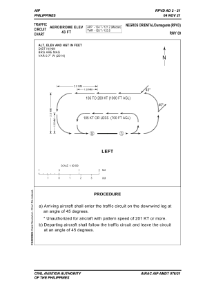
VAC chart of RPVD
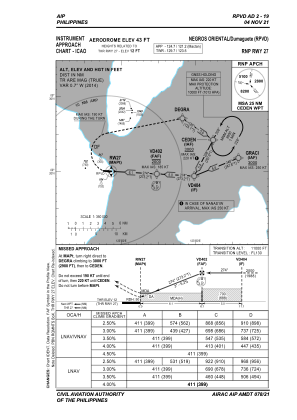
 IAC chart of RPVD
 Satellite view of RPVD

IAC chart of RPVD
Satellite view of RPVD
Sorry, we have no imagery here.
Sorry, we have no imagery here.
Sorry, we have no imagery here.
Sorry, we have no imagery here.
Sorry, we have no imagery here.
Sorry, we have no imagery here.


RPVD - Dumaguete Principal Airport (Class 1)
Located in Dumaguete City, Philippines
ICAO - RPVD, IATA - DGT
Data provided by AirmateGeneral information
Coordinates: N9°20'3" E123°18'7"
Elevation is 42 feet MSL.
Magnetic variation is -2° East View others Airports in Negros Oriental
Operational data
Special qualification required
Current time UTC:
Current local time:
Weather
TAF: TAF RPVD 071700Z 0718/0818 32006KT 9999 FEW015 SCT070 TEMPO 0718/0724 27006KT SCT015 BKN070 BECMG 0802/0804 04008KT
Communications frequencies: [VIEW]
Runways:
| RWY identifier | QFU | Length (ft) | Width (ft) | Surface | LDA (ft) |
| 09 | 93° | 6053 | 148 | CONC+ASPH | 6053 |
| 27 | 273° | 6053 | 148 | CONC+ASPH | 6053 |
Airport contact information
Address: Dumaguete City Philippines
Satellite view of RPVD
Sorry, we have no imagery here.
Sorry, we have no imagery here.
Sorry, we have no imagery here.
Sorry, we have no imagery here.
Sorry, we have no imagery here.
Sorry, we have no imagery here.