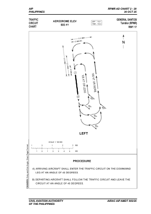
VAC chart of RPMR
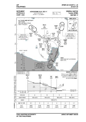
 IAC chart of RPMR
 Satellite view of RPMR
IAC chart of RPMR
Satellite view of RPMR
Sorry, we have no imagery here.
Sorry, we have no imagery here.
Sorry, we have no imagery here.
Sorry, we have no imagery here.
Sorry, we have no imagery here.
Sorry, we have no imagery here.


RPMR - Tambler Principal Airport
Located in General Santos City, Philippines
ICAO - RPMR, IATA - GES
Data provided by AirmateGeneral information
Coordinates: N6°3'29" E125°5'46"
Elevation is 501 feet MSL.
Magnetic variation is -1° East View others Airports in South Cotabato
Operational data
Special qualification required
Current time UTC:
Current local time:
Communications frequencies: [VIEW]
Runways:
| RWY identifier | QFU | Length (ft) | Width (ft) | Surface | LDA (ft) |
| 17 | 173° | 10587 | 148 | CONC | 10587 |
| 35 | 353° | 10587 | 148 | CONC | 10587 |
Airport contact information
Address: General Santos City Philippines
Satellite view of RPMR
Sorry, we have no imagery here.
Sorry, we have no imagery here.
Sorry, we have no imagery here.
Sorry, we have no imagery here.
Sorry, we have no imagery here.
Sorry, we have no imagery here.