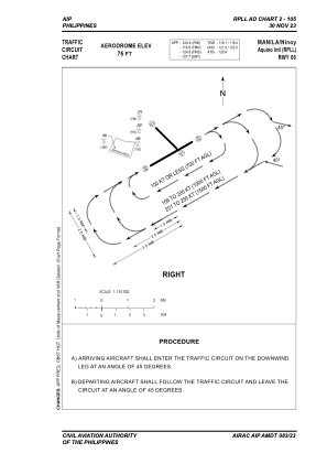
VAC chart of RPLL
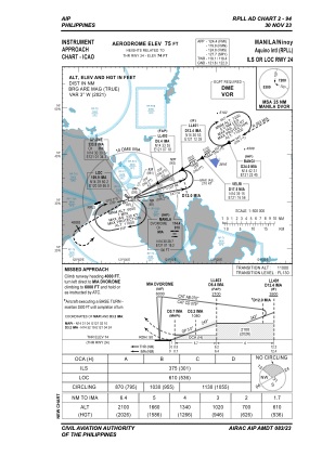
 IAC chart of RPLL
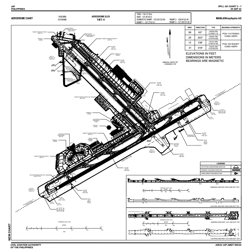
 ADC chart of RPLL
 Satellite view of RPLL
IAC chart of RPLLADC chart of RPLL
Satellite view of RPLL
Sorry, we have no imagery here.
Sorry, we have no imagery here.
Sorry, we have no imagery here.
Sorry, we have no imagery here.
Sorry, we have no imagery here.
Sorry, we have no imagery here.


RPLL - Ninoy Aquino International Airport
Located in Manila, Philippines
ICAO - RPLL, IATA - MNL
Data provided by AirmateGeneral information
Coordinates: N14°30'36" E121°0'49"
Elevation is 75 feet MSL.
Magnetic variation is -3° East Operational data
Special qualification required
Current time UTC:
Current local time:
Weather
METAR: RPLL 290300Z VRB05KT 9999 SCT025 BKN100 29/26 Q1011 NOSIG RMK A2985
TAF: TAF RPLL 282300Z 2900/3006 12007KT 9999 FEW025 BKN100 TX32/2906Z TN26/2921Z TEMPO 2902/2908 14013KT -RA SCT025 OVC090
Communications frequencies: [VIEW]
Runways:
| RWY identifier | QFU | Length (ft) | Width (ft) | Surface | LDA (ft) |
| 06 | 60° | 11529 | 197 | CONC+ASPH | 11184 |
| 24 | 240° | 11529 | 197 | CONC+ASPH | 11184 |
| 13 | 135° | 7379 | 148 | CONC+ASPH | 6906 |
| 31 | 315° | 7379 | 148 | CONC+ASPH |
Airport contact information
Address: Manila Philippines
Satellite view of RPLL
Sorry, we have no imagery here.
Sorry, we have no imagery here.
Sorry, we have no imagery here.
Sorry, we have no imagery here.
Sorry, we have no imagery here.
Sorry, we have no imagery here.