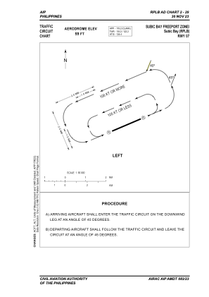
VAC chart of RPLB
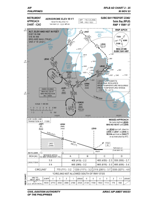
 IAC chart of RPLB
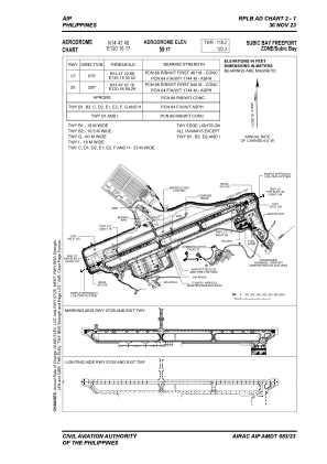
 ADC chart of RPLB
 Satellite view of RPLB
IAC chart of RPLBADC chart of RPLB
Satellite view of RPLB
Sorry, we have no imagery here.
Sorry, we have no imagery here.
Sorry, we have no imagery here.
Sorry, we have no imagery here.
Sorry, we have no imagery here.
Sorry, we have no imagery here.


RPLB - Subic Bay International Airport
Located in Subic Bay, Philippines
ICAO - RPLB, IATA - SFS
Data provided by AirmateGeneral information
Coordinates: N14°47'40" E120°16'17"
Elevation is 59 feet MSL.
Magnetic variation is -3° East View others Airports in Zambales
Operational data
Special qualification required
Current time UTC:
Current local time:
Communications frequencies: [VIEW]
Runways:
| RWY identifier | QFU | Length (ft) | Width (ft) | Surface | LDA (ft) |
| 07 | 67° | 9006 | 148 | CONC | 9006 |
| 25 | 247° | 9006 | 148 | CONC | 9006 |
Airport contact information
Address: Subic Bay Philippines
Satellite view of RPLB
Sorry, we have no imagery here.
Sorry, we have no imagery here.
Sorry, we have no imagery here.
Sorry, we have no imagery here.
Sorry, we have no imagery here.
Sorry, we have no imagery here.