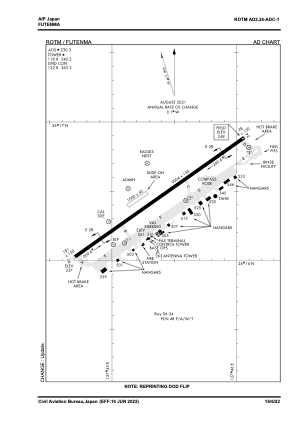
ADC chart of ROTM
 Satellite view of ROTM
Satellite view of ROTM
Sorry, we have no imagery here.
Sorry, we have no imagery here.
Sorry, we have no imagery here.
Sorry, we have no imagery here.
Sorry, we have no imagery here.
Sorry, we have no imagery here.


ROTM - Futenma
Located in Naha, Japan
ICAO - ROTM, IATA -
Data provided by AirmateGeneral information
Coordinates: N26°16'15" E127°44'53"
Elevation is 248 feet MSL.
View others Airports in Okinawa Prefecture
Operational data
Special qualification required
Current time UTC:
Current local time:
Weather
METAR: ROTM 262356Z AUTO 11013KT 10SM OVC090 A3003 RMK AO2 SLPNO 54000 $
Communications frequencies: [VIEW]
Runways:
| RWY identifier | QFU | Length (ft) | Width (ft) | Surface | LDA (ft) |
| 06 | 55° | 9004 | 150 | ASP | |
| 24 | 235° | 9004 | 150 | ASP |
Airport contact information
Address: Naha Japan
Satellite view of ROTM
Sorry, we have no imagery here.
Sorry, we have no imagery here.
Sorry, we have no imagery here.
Sorry, we have no imagery here.
Sorry, we have no imagery here.
Sorry, we have no imagery here.