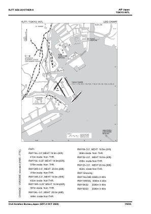
VAC chart of RJTT
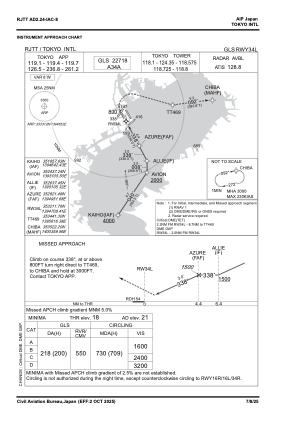
 IAC chart of RJTT
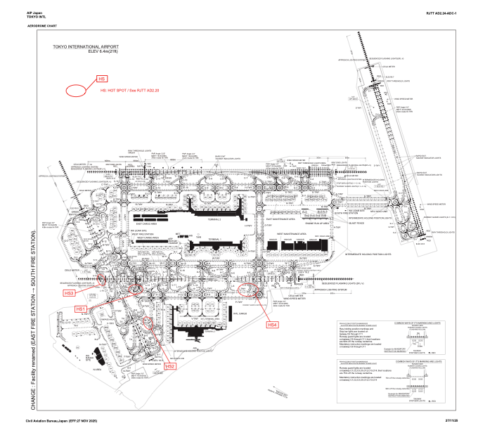
 ADC chart of RJTT
 Satellite view of RJTT
IAC chart of RJTTADC chart of RJTT
Satellite view of RJTT
Sorry, we have no imagery here.
Sorry, we have no imagery here.
Sorry, we have no imagery here.
Sorry, we have no imagery here.
Sorry, we have no imagery here.
Sorry, we have no imagery here.


RJTT - Tokyo Intl
Located in Tokyo, Japan
ICAO - RJTT, IATA - HND
Data provided by AirmateGeneral information
Coordinates: N35°33'12" E139°46'52"
Elevation is 21 feet MSL.
View others Airports in Tokyo Prefecture
Operational data
Special qualification required
Current time UTC:
Current local time:
Weather
METAR: RJTT 282200Z 04015KT 8000 -RA FEW006 SCT008 BKN015 10/09 Q1013 TEMPO 4000 -RA BR FEW005 BKN008
TAF: TAF AMD RJTT 282041Z 2820/3000 05014KT 8000 -RA FEW008 BKN015 TEMPO 2820/2900 4000 -RA BR FEW005 BKN008 TEMPO 2900/2904 3000 RA BR FEW003 BKN005 BECMG 2912/2915 35008KT
Communications frequencies: [VIEW]
Runways:
| RWY identifier | QFU | Length (ft) | Width (ft) | Surface | LDA (ft) |
| 16L | 150° | 11024 | 197 | ASP | |
| 34R | 330° | 11024 | 197 | ASP | |
| 04 | 35° | 8202 | 197 | ASP | |
| 22 | 215° | 8202 | 197 | ASP | |
| 05 | 43° | 8202 | 197 | ASP | |
| 23 | 223° | 8202 | 197 | ASP | |
| 16R | 150° | 9843 | 197 | ASP | |
| 34L | 330° | 9843 | 197 | ASP |
Airport contact information
Address: Tokyo Japan
Satellite view of RJTT
Sorry, we have no imagery here.
Sorry, we have no imagery here.
Sorry, we have no imagery here.
Sorry, we have no imagery here.
Sorry, we have no imagery here.
Sorry, we have no imagery here.