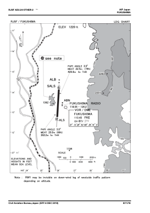
VAC chart of RJSF
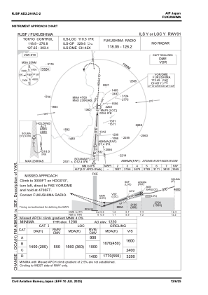
 IAC chart of RJSF
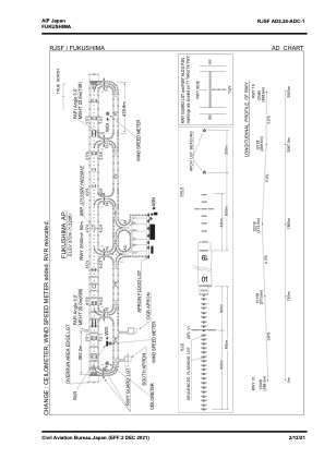
 ADC chart of RJSF
 Satellite view of RJSF

IAC chart of RJSFADC chart of RJSF
Satellite view of RJSF
Sorry, we have no imagery here.
Sorry, we have no imagery here.
Sorry, we have no imagery here.
Sorry, we have no imagery here.
Sorry, we have no imagery here.


RJSF - Fukushima
Located in Koriyama, Japan
ICAO - RJSF, IATA - FKS
Data provided by AirmateGeneral information
Coordinates: N37°13'39" E140°25'41"
Elevation is 1220 feet MSL.
View others Airports in Fukusima Prefecture
Operational data
Special qualification required
Current time UTC:
Current local time:
Weather
TAF: TAF RJSF 181105Z 1812/1918 36006KT 9999 FEW020 BKN040 BECMG 1818/1820 35016KT 3000 -SN FEW003 BKN008 TEMPO 1819/1900 0500 -SN FEW001 BKN003 TEMPO 1900/1903 1500 -SN FEW003 BKN005 BECMG 1906/1909 9999 NSW FEW015 BKN030
Communications frequencies: [VIEW]
Runways:
| RWY identifier | QFU | Length (ft) | Width (ft) | Surface | LDA (ft) |
| 01 | 2° | 8202 | 197 | ASP | |
| 19 | 182° | 8202 | 197 | ASP |
Airport contact information
Address: Koriyama Japan
Satellite view of RJSF
Sorry, we have no imagery here.
Sorry, we have no imagery here.
Sorry, we have no imagery here.
Sorry, we have no imagery here.
Sorry, we have no imagery here.