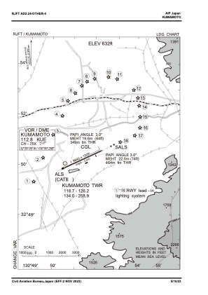
VAC chart of RJFT
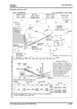
 IAC chart of RJFT
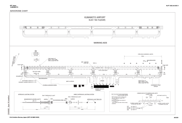
 ADC chart of RJFT
 Satellite view of RJFT

IAC chart of RJFTADC chart of RJFT
Satellite view of RJFT
Sorry, we have no imagery here.
Sorry, we have no imagery here.
Sorry, we have no imagery here.
Sorry, we have no imagery here.
Sorry, we have no imagery here.
Sorry, we have no imagery here.


RJFT - Kumamoto
Located in Kumamoto, Japan
ICAO - RJFT, IATA - KMJ
Data provided by AirmateGeneral information
Coordinates: N32°50'14" E130°51'19"
Elevation is 632 feet MSL.
View others Airports in Kumamoto Prefecture
Operational data
Special qualification required
Current time UTC:
Current local time:
Weather
METAR: RJFT 110700Z 19007KT 140V220 9999 FEW045 21/11 Q1009
TAF: TAF RJFT 110505Z 1106/1212 26008KT 9999 FEW035 SCT045 BECMG 1110/1112 04004KT
Communications frequencies: [VIEW]
Runways:
| RWY identifier | QFU | Length (ft) | Width (ft) | Surface | LDA (ft) |
| 07 | 65° | 9843 | 148 | ASP | |
| 25 | 245° | 9843 | 148 | ASP |
Airport contact information
Address: Kumamoto Japan
Satellite view of RJFT
Sorry, we have no imagery here.
Sorry, we have no imagery here.
Sorry, we have no imagery here.
Sorry, we have no imagery here.
Sorry, we have no imagery here.
Sorry, we have no imagery here.