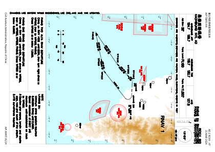
IAC chart of RCKH
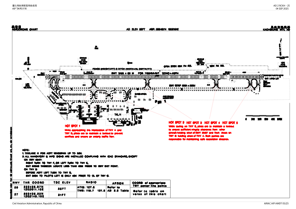
 ADC chart of RCKH
 Satellite view of RCKH
ADC chart of RCKH
Satellite view of RCKH
Sorry, we have no imagery here.
Sorry, we have no imagery here.
Sorry, we have no imagery here.
Sorry, we have no imagery here.
Sorry, we have no imagery here.
Sorry, we have no imagery here.


RCKH - Kaohsiung Intl
Located in Kaohsiung, Taiwan, Province of China
ICAO - RCKH, IATA - KHH
Data provided by AirmateGeneral information
Coordinates: N22°34'37" E120°21'1"
Elevation is 31 feet MSL.
View others Airports in Kaohsiung (municipality)
Operational data
Special qualification required
Current time UTC:
Current local time:
Weather
METAR: RCKH 181700Z 18004KT 160V230 9999 FEW010 BKN018 29/26 Q1010 NOSIG RMK A2983
TAF: TAF RCKH 181700Z 1818/1924 17005KT 9999 FEW015 BKN032 TEMPO 1818/1824 09005KT BECMG 1900/1902 20010KT TEMPO 1904/1910 27013KT BECMG 1912/1914 18005KT
Communications frequencies: [VIEW]
Runways:
| RWY identifier | QFU | Length (ft) | Width (ft) | Surface | LDA (ft) |
| 09 | 92° | 10335 | 197 | CON | |
| 27 | 272° | 10335 | 197 | CON |
Airport contact information
Address: Kaohsiung Taiwan, Province of China
Satellite view of RCKH
Sorry, we have no imagery here.
Sorry, we have no imagery here.
Sorry, we have no imagery here.
Sorry, we have no imagery here.
Sorry, we have no imagery here.
Sorry, we have no imagery here.