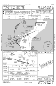
IAC chart of PGUM
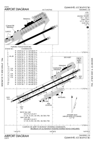
 ADC chart of PGUM
 Satellite view of PGUM
ADC chart of PGUM
Satellite view of PGUM
Sorry, we have no imagery here.
Sorry, we have no imagery here.
Sorry, we have no imagery here.
Sorry, we have no imagery here.
Sorry, we have no imagery here.
Sorry, we have no imagery here.


PGUM - Guam Intl
Located in Guam, Guam
ICAO - GUM, IATA - GUM
Data provided by AirmateGeneral information
Coordinates: N13°29'2" E144°47'50"
Elevation is 305 feet MSL.
Magnetic variation is 02° East View others Airports in (unassigned)
Operational data
Special qualification required
Current time UTC:
Current local time:
Weather
METAR: PGUM 220254Z 11010G18KT 10SM SCT025 32/23 A2979 RMK AO2 SLP080 T03170233 58018
TAF: PGUM 212336Z 2200/2306 08010KT P6SM VCSH FEW021 SCT130
Communications frequencies: [VIEW]
Runways:
| RWY identifier | QFU | Length (ft) | Width (ft) | Surface | LDA (ft) |
| 06L | 65° | 12014 | 150 | CONC+ASPH | 11014 |
| 24R | 245° | 12014 | 150 | CONC+ASPH | 12014 |
| 06R | 65° | 10014 | 150 | CONC+ASPH | 10014 |
| 24L | 245° | 10014 | 150 | CONC+ASPH | 8710 |
Airport contact information
Address: Guam Guam
Other aviation service providers
Flight schools

Satellite view of PGUM
Sorry, we have no imagery here.
Sorry, we have no imagery here.
Sorry, we have no imagery here.
Sorry, we have no imagery here.
Sorry, we have no imagery here.
Sorry, we have no imagery here.