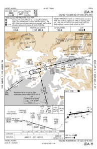


PAVD - Valdez Pioneer Fld
Located in Valdez,
ICAO - VDZ, IATA - VDZ
Data provided by AirmateGeneral information
Coordinates: N61°8'3" W146°14'41"
Elevation is 128 feet MSL.
Magnetic variation is 19° East View others Airports in Alaska
Operational data
Special qualification required
Current time UTC:
Current local time:
Weather
METAR: PAVD 162256Z 00000KT 10SM SCT080 BKN100 BKN120 03/00 A2976 RMK AO2 SLP078 T00280000 PNO $
TAF: PAVD 162320Z 1700/1724 VRB04KT P6SM SCT080 FM170200 07006KT P6SM SCT100 FM171200 07008G28KT P6SM BKN100
Communications frequencies: [VIEW]
Runways:
| RWY identifier | QFU | Length (ft) | Width (ft) | Surface | LDA (ft) |
| 06 | 81° | 6500 | 150 | ASPH | 6500 |
| 24 | 261° | 6500 | 150 | ASPH | 6500 |
Airport contact information
Address: Valdez