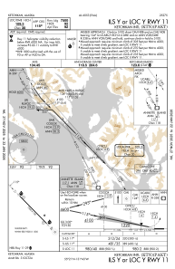
IAC chart of PAKT
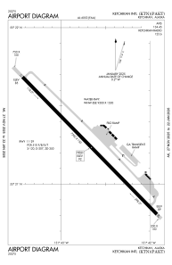
 ADC chart of PAKT
 Satellite view of PAKT

ADC chart of PAKT
Satellite view of PAKT
Sorry, we have no imagery here.
Sorry, we have no imagery here.
Sorry, we have no imagery here.
Sorry, we have no imagery here.
Sorry, we have no imagery here.
Sorry, we have no imagery here.


PAKT - Ketchikan Intl
Located in Ketchikan,
ICAO - KTN, IATA - KTN
Data provided by AirmateGeneral information
Coordinates: N55°21'15" W131°42'40"
Elevation is 92 feet MSL.
Magnetic variation is 21° East View others Airports in Alaska
Operational data
Special qualification required
Current time UTC:
Current local time:
Weather
METAR: PAKT 150753Z AUTO 00000KT 10SM SCT044 OVC055 00/M01 A2948 RMK AO2 SLP983 T00001011 TSNO
TAF: PAKT 150527Z 1506/1606 VRB04KT P6SM SCT025 BKN050 TEMPO 1506/1508 4SM -SN BR BKN020 OVC030 FM152000 13008KT P6SM OVC050 PROB30 1520/1524 -SNRA OVC030 FM160000 VRB04KT 4SM -SNRA BKN025 OVC040 AMD LTD TO CLD VIS AND WIND 1506/1515
Communications frequencies: [VIEW]
Runways:
| RWY identifier | QFU | Length (ft) | Width (ft) | Surface | LDA (ft) |
| 11 | 136° | 7500 | 150 | ASPH | |
| 29 | 316° | 7500 | 150 | ASPH | |
| WNW | 0° | 9500 | 1500 | WATER | |
| ESE | 0° | 9500 | 1500 | WATER |
Airport contact information
Address: Ketchikan
Satellite view of PAKT
Sorry, we have no imagery here.
Sorry, we have no imagery here.
Sorry, we have no imagery here.
Sorry, we have no imagery here.
Sorry, we have no imagery here.
Sorry, we have no imagery here.