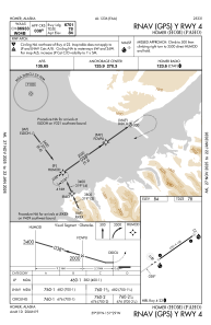
IAC chart of PAHO
 Satellite view of PAHO
Satellite view of PAHO
Sorry, we have no imagery here.
Sorry, we have no imagery here.
Sorry, we have no imagery here.
Sorry, we have no imagery here.
Sorry, we have no imagery here.
Sorry, we have no imagery here.


PAHO - Homer
Located in Homer,
ICAO - HOM, IATA - HOM
Data provided by AirmateGeneral information
Coordinates: N59°38'44" W151°28'36"
Elevation is 84 feet MSL.
Magnetic variation is 17° East View others Airports in Alaska
Operational data
Special qualification required
Current time UTC:
Current local time:
Weather
METAR: PAHO 181500Z 00000KT 8SM -RA SCT006 BKN011 OVC021 07/06 A2981 RMK AO2 RAB1456 P0000 T00720056 $
TAF: PAHO 181143Z 1812/1912 VRB04KT P6SM FEW040 OVC060 FM181900 23009KT P6SM VCSH SCT025 BKN040
Communications frequencies: [VIEW]
Runways:
| RWY identifier | QFU | Length (ft) | Width (ft) | Surface | LDA (ft) |
| 04 | 55° | 6701 | 150 | ASPH | |
| 22 | 235° | 6701 | 150 | ASPH |
Airport contact information
Address: Homer
Satellite view of PAHO
Sorry, we have no imagery here.
Sorry, we have no imagery here.
Sorry, we have no imagery here.
Sorry, we have no imagery here.
Sorry, we have no imagery here.
Sorry, we have no imagery here.