


PAGA - Edward G Pitka Sr
Located in Galena,
ICAO - GAL, IATA - GAL
Data provided by AirmateGeneral information
Coordinates: N64°44'10" W156°56'4"
Elevation is 154 feet MSL.
Magnetic variation is 13° East View others Airports in Alaska
Operational data
Special qualification required
Current time UTC:
Current local time:
Weather
METAR: PAGA 120856Z AUTO 35003KT 10SM OVC055 08/06 A2958 RMK AO2 SLP017 T00830061 401220072 58007 TSNO $
TAF: PAGA 120540Z 1206/1306 01003KT P6SM SCT020 BKN050 FM121200 33003KT P6SM BKN020 BKN050 FM121800 36006KT P6SM FEW025 BKN050 FM130500 33004KT P6SM SCT015 OVC030
Communications frequencies: [VIEW]
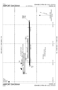
Runways:
| RWY identifier | QFU | Length (ft) | Width (ft) | Surface | LDA (ft) |
| 06 | 90° | 2600 | 50 | GRAVEL | |
| 24 | 270° | 2600 | 50 | GRAVEL | |
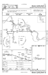
| 08 | 90° | 6000 | 100 | ASPH | 5600 |
| 26 | 270° | 6000 | 100 | ASPH | 5200 |
Airport contact information
Address: Galena