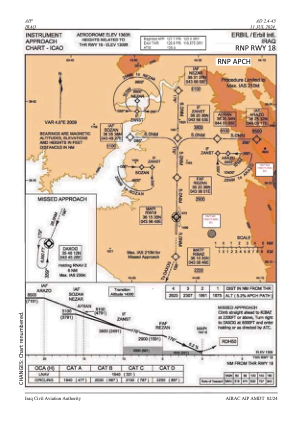
IAC chart of ORER
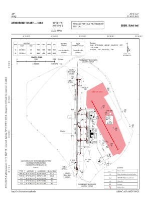
 ADC chart of ORER
 Satellite view of ORER
ADC chart of ORER
Satellite view of ORER
Sorry, we have no imagery here.
Sorry, we have no imagery here.
Sorry, we have no imagery here.
Sorry, we have no imagery here.
Sorry, we have no imagery here.
Sorry, we have no imagery here.


ORER - Erbil International Airport
Located in Erbil, Iraq
ICAO - ORER, IATA - EBL
Data provided by AirmateGeneral information
Coordinates: N36°14'17" E43°56'48"
Elevation is 1363 feet MSL.
View others Airports in Arbil Governorate
Operational data
Special qualification required
Current time UTC:
Current local time:
Weather
TAF: TAF ORER 241100Z 2412/2512 25012KT 6000 SCT035 SCT090 PROB30 TEMPO 2412/2418 26012G28KT 3000 -TSRA BLDU FEW025CB BECMG 2420/2422 06009KT
Communications frequencies: [VIEW]
Runways:
| RWY identifier | QFU | Length (ft) | Width (ft) | Surface | LDA (ft) |
| 18 | 180° | 15748 | 246 | U | |
| 36 | 0° | 15748 | 246 | U |
Airport contact information
Address: Erbil Iraq
Satellite view of ORER
Sorry, we have no imagery here.
Sorry, we have no imagery here.
Sorry, we have no imagery here.
Sorry, we have no imagery here.
Sorry, we have no imagery here.
Sorry, we have no imagery here.