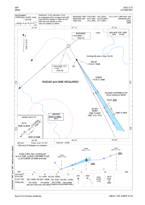
IAC chart of ORBI
 ADC chart of ORBI
 Satellite view of ORBI
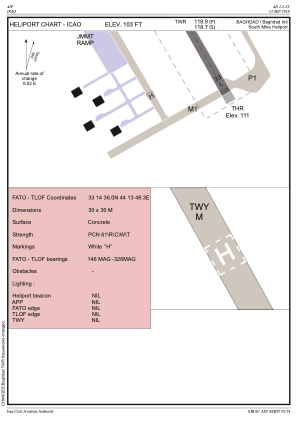
ADC chart of ORBI
Satellite view of ORBI
Sorry, we have no imagery here.
Sorry, we have no imagery here.
Sorry, we have no imagery here.
Sorry, we have no imagery here.
Sorry, we have no imagery here.
Sorry, we have no imagery here.


ORBI - Baghdad International Airport
Located in Baghdad, Iraq
ICAO - ORBI, IATA - BGW
Data provided by AirmateGeneral information
Coordinates: N33°15'45" E44°14'4"
Elevation is 114 feet MSL.
View others Airports in Baghdad Governorate
Operational data
Special qualification required
Current time UTC:
Current local time:
Weather
METAR: ORBI 220900Z 35011KT 310V020 CAVOK 41/02 Q1007 NOSIG
TAF: TAF ORBI 220500Z 2206/2306 34008KT CAVOK
Communications frequencies: [VIEW]
Runways:
| RWY identifier | QFU | Length (ft) | Width (ft) | Surface | LDA (ft) |
| 15R | 150° | 10830 | 148 | CON | |
| 33L | 330° | 10830 | 148 | CON | |
| 15L | 150° | 13123 | 197 | CON | |
| 33R | 330° | 13123 | 197 | CON |
Airport contact information
Address: Baghdad Iraq
Satellite view of ORBI
Sorry, we have no imagery here.
Sorry, we have no imagery here.
Sorry, we have no imagery here.
Sorry, we have no imagery here.
Sorry, we have no imagery here.
Sorry, we have no imagery here.