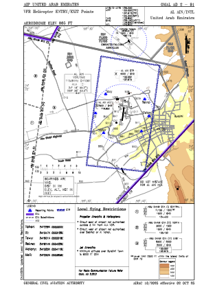
VAC chart of OMAL
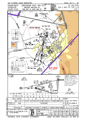
 IAC chart of OMAL
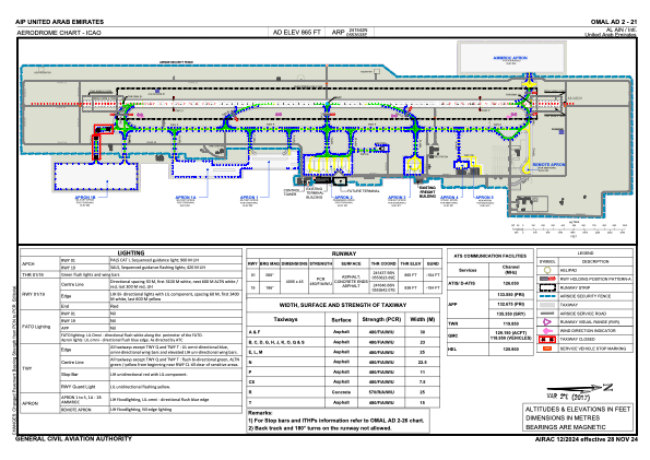
 ADC chart of OMAL
 Satellite view of OMAL
IAC chart of OMALADC chart of OMAL
Satellite view of OMAL
Sorry, we have no imagery here.
Sorry, we have no imagery here.
Sorry, we have no imagery here.
Sorry, we have no imagery here.
Sorry, we have no imagery here.
Sorry, we have no imagery here.


OMAL - Al Ain / International
Located in Al Ain, United Arab Emirates
ICAO - OMAL, IATA - AAN
Data provided by AirmateGeneral information
Coordinates: N24°15'42" E55°36'33"
Elevation is 866 feet MSL.
View others Airports in Abu Dhabi Emirate
Operational data
Special qualification required
Current time UTC:
Current local time:
Weather
METAR: OMAL 191000Z 29005KT CAVOK 43/04 Q1004 NOSIG
TAF: TAF OMAL 190500Z 1906/2012 04005KT 8000 NSC BECMG 1907/1909 34012KT PROB30 TEMPO 1911/1914 34015G25KT 4000 BLDU BECMG 1920/1922 10006KT BECMG 2000/2002 16014KT BECMG 2008/2010 23006KT BECMG 2010/2012 34014KT
Communications frequencies: [VIEW]
Runways:
| RWY identifier | QFU | Length (ft) | Width (ft) | Surface | LDA (ft) |
| 01 | 7° | 13140 | 148 | ASP | |
| 19 | 187° | 13140 | 148 | ASP |
Airport contact information
Address: Al Ain United Arab Emirates
Satellite view of OMAL
Sorry, we have no imagery here.
Sorry, we have no imagery here.
Sorry, we have no imagery here.
Sorry, we have no imagery here.
Sorry, we have no imagery here.
Sorry, we have no imagery here.