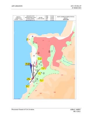
VAC chart of OLBA
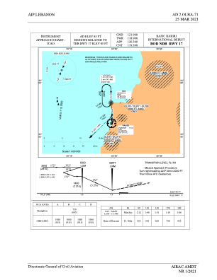
 IAC chart of OLBA
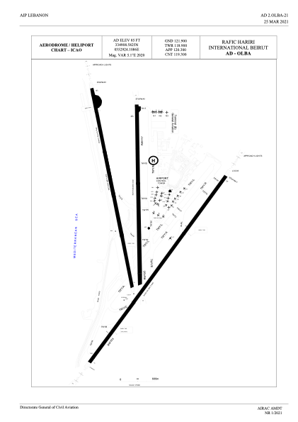
 ADC chart of OLBA
 Satellite view of OLBA
IAC chart of OLBAADC chart of OLBA
Satellite view of OLBA
Sorry, we have no imagery here.
Sorry, we have no imagery here.
Sorry, we have no imagery here.
Sorry, we have no imagery here.
Sorry, we have no imagery here.
Sorry, we have no imagery here.


OLBA - Rafic Hariri International Beirut
Located in Beirut, Lebanon
ICAO - OLBA, IATA - BEY
Data provided by AirmateGeneral information
Coordinates: N33°49'9" E35°29'24"
Elevation is 85 feet MSL.
View others Airports in Mount Lebanon Governorate
Operational data
Special qualification required
Current time UTC:
Current local time:
Weather
METAR: OLBA 191900Z 22005KT 8000 FEW026 21/15 Q1017 NOSIG
TAF: TAF OLBA 191600Z 1918/2018 16010KT 8000 BKN050 TX25/2010Z TN19/2002Z BECMG 2006/2009 23010KT BECMG 2015/2018 17010KT
Communications frequencies: [VIEW]
Runways:
| RWY identifier | QFU | Length (ft) | Width (ft) | Surface | LDA (ft) |
| 03 | 33° | 12467 | 148 | CON | |
| 21 | 213° | 12467 | 148 | CON | |
| 16 | 167° | 11138 | 148 | CON | |
| 34 | 347° | 11138 | 148 | CON | |
| 17 | 177° | 10663 | 148 | ASP | |
| 35 | 357° | 10663 | 148 | ASP |
Airport contact information
Address: Beirut Lebanon
Satellite view of OLBA
Sorry, we have no imagery here.
Sorry, we have no imagery here.
Sorry, we have no imagery here.
Sorry, we have no imagery here.
Sorry, we have no imagery here.
Sorry, we have no imagery here.