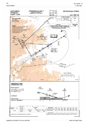
IAC chart of OENG
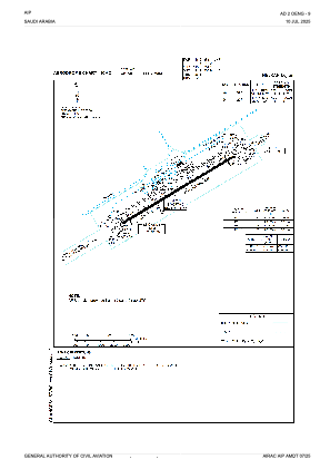
 ADC chart of OENG
 Satellite view of OENG
ADC chart of OENG
Satellite view of OENG
Sorry, we have no imagery here.
Sorry, we have no imagery here.
Sorry, we have no imagery here.
Sorry, we have no imagery here.
Sorry, we have no imagery here.
Sorry, we have no imagery here.


OENG - Nejran
Located in Nejran, Saudi Arabia
ICAO - OENG, IATA - EAM
Data provided by AirmateGeneral information
Coordinates: N17°36'41" E44°25'9"
Elevation is 3983 feet MSL.
View others Airports in Najran
Operational data
Special qualification required
Current time UTC:
Current local time:
Weather
METAR: OENG 061200Z 09006KT 030V120 9999 FEW030 35/M01 Q1014 NOSIG
TAF: TAF OENG 061100Z 0612/0718 09010KT 9999 FEW030 PROB30 TEMPO 0612/0700 TS FEW025CB SCT030 BECMG 0618/0620 VRB03KT BECMG 0706/0708 13012KT
Communications frequencies: [VIEW]
Runways:
| RWY identifier | QFU | Length (ft) | Width (ft) | Surface | LDA (ft) |
| 06 | 60° | 10007 | 148 | ASP | |
| 24 | 240° | 10007 | 148 | ASP |
Airport contact information
Address: Nejran Saudi Arabia
Satellite view of OENG
Sorry, we have no imagery here.
Sorry, we have no imagery here.
Sorry, we have no imagery here.
Sorry, we have no imagery here.
Sorry, we have no imagery here.
Sorry, we have no imagery here.