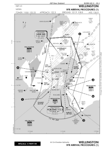
VAC chart of NZWN
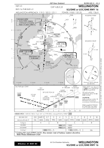
 IAC chart of NZWN
 Satellite view of NZWN
IAC chart of NZWN
Satellite view of NZWN
Sorry, we have no imagery here.
Sorry, we have no imagery here.
Sorry, we have no imagery here.
Sorry, we have no imagery here.
Sorry, we have no imagery here.
Sorry, we have no imagery here.


NZWN - Wellington
Located in Wellington, New Zealand
ICAO - NZWN, IATA - WLG
Data provided by AirmateGeneral information
Coordinates: S41°19'38" E174°48'19"
Elevation is 41 feet MSL.
Magnetic variation is +23° East View others Airports in Wellington Region
Operational data
Special qualification required
Current time UTC:
Current local time:
Communications frequencies: [VIEW]
Runways:
| RWY identifier | QFU | Length (ft) | Width (ft) | Surface | LDA (ft) |
| 16 | 183° | 5955 | 148 | BITUM | 5955 |
| 34 | 3° | 5955 | 148 | BITUM | 5955 |
Airport contact information
Address: Wellington New Zealand
Other aviation service providers
Flight schools

Airways Corporation Of New Zealand Limited
Airways Corporation Of New Zealand Limited
trainingadmin@airways.co.nz+6444711888
Aviation club (not for profit)

Satellite view of NZWN
Sorry, we have no imagery here.
Sorry, we have no imagery here.
Sorry, we have no imagery here.
Sorry, we have no imagery here.
Sorry, we have no imagery here.
Sorry, we have no imagery here.