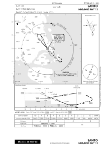
IAC chart of NVSS
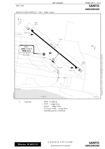
 ADC chart of NVSS
 Satellite view of NVSS
ADC chart of NVSS
Satellite view of NVSS
Sorry, we have no imagery here.
Sorry, we have no imagery here.
Sorry, we have no imagery here.
Sorry, we have no imagery here.
Sorry, we have no imagery here.
Sorry, we have no imagery here.


NVSS - Santo
Located in Luganville, Vanuatu
ICAO - NVSS, IATA - SON
Data provided by AirmateGeneral information
Coordinates: S15°30'21" E167°13'17"
Elevation is 184 feet MSL.
View others Airports in Sanma
Operational data
Special qualification required
Current time UTC:
Current local time:
Weather
METAR: NVSS 222000Z VRB02KT 9999 FEW020 SCT290 24/24 Q1009
TAF: TAF NVSS 221700Z 2218/2318 02005KT 9999 SCT020 BKN040 INTER 2218/2222 8000 SHRA FEW010 BKN018 OVC090 PROB40 INTER 2220/2224 6000 TSRA SCT008 BKN016 FEW020CB OVC090
Communications frequencies: [VIEW]
Runways:
| RWY identifier | QFU | Length (ft) | Width (ft) | Surface | LDA (ft) |
| 12 | 129° | 6562 | 98 | ASP | |
| 30 | 309° | 6562 | 98 | ASP |
Airport contact information
Address: Luganville Vanuatu
Satellite view of NVSS
Sorry, we have no imagery here.
Sorry, we have no imagery here.
Sorry, we have no imagery here.
Sorry, we have no imagery here.
Sorry, we have no imagery here.
Sorry, we have no imagery here.